Landmarks
The pass
The old pass through the nearby Van Staden’s Gorge was a watering place for wagons coming up from the Cape – it was, in fact, the gateway to the big game hunting fields of old Africa.
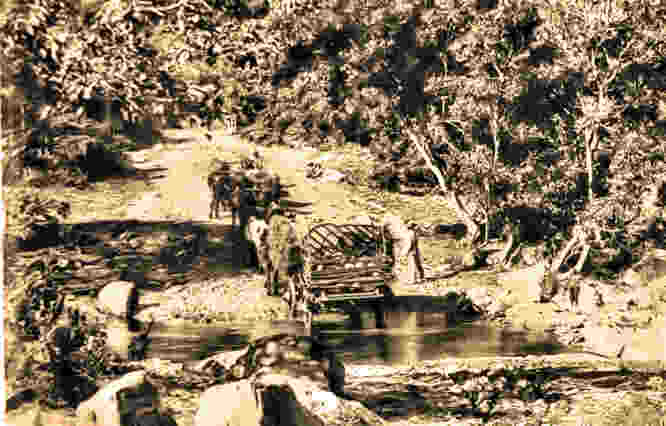
The drift at the bottom of the Van Stadens Pass as it looked in 1904 with a ox-wagon crossing the river
The original pass was named after one of the area’s pioneer farmers – Marthinus van Staden, as he was the first person to plot a rudimentary track through the Van Stadens River Gorge. By 1867 the Cape Government decided to rebuild the pass to acceptable standards for wagon traffic. The actual construction was done by George Apsey from 1865 to 1867 (“Governor’s Travels” by Bartle Logie, page 19 to 21).
A year after the construction in 1868 a massive flood washed away major sections of the pass and bridge resulting in a complete rebuild.
On the Port Elizabeth side of the Van Staden’s Pass through the van Stadens river it is recorded that in 1870 there was a toll that covered the area at the entrance to Yellowwoods farm and Woodridge school where the old Cadle’s hotel stood in the coaching days.
The locals still refer to this place as “ eToleni”, referring to the toll.
Constant improvements and widening took place over the next hundred and twenty years. It was tarred between 1950 and 1953.
The pass served the Eastern Cape community well up till 1971 when the N2 with the Van Stadens bridge were completed.
Lady’s Slipper
The distinctive Lady’s Slipper rock formation on the mountain is a well-known feature that early travellers used as a beacon, or marker, to guide them.
It was also used as a gathering place where wagons were outspanned and the oxen allowed to rest and graze while the weary travellers rested.
In 1990 P.E. Schonland named the van Stadens berg van Stadens hoogte.
The colloquial name for area around upper van Stadens river is “van Stadens”
Railway Bridge
The van Stadens railway bridge is the second-highest (77 meters high)narrow-gauge bridge in Africa, after the railway bridge at Victoria Falls.
This spindly-looking steel bridge being 156m long, 77m high and containing 1 112 cubic metres of concrete and 574 tons of steel is along the longest 2ft (610mm) narrow-gauge railway line in the world.
A 285km line built to ferry fruit from the Langkloof region to the harbour in Port Elizabeth.
But the rise of road freight haulage in South Africa – helped by the big road bridges along the N2, no doubt – eventually put paid to the railway line’s viability, and it sees little traffic today.
This narrow gauge line from Port Elizabeth was authorised in 1899 and construction commenced in 1902, reaching the town of Avontuur in the Langkloof late in 1906. The line was built to connect the scenic Langkloof with its fruit growing industry to the port of Port Elizabeth. The official opening of the line was in 1907, with a main line track length of 284km (177 miles) from Port Elizabeth to Avontuur. The 30km branch line from Gamtoos Junction to Patensie was completed in 1914 to serve this citrus producing area. The establishment of the deciduous fruit industry in the Langkloof, and the use of the Narrow Gauge to transport fruit to the cooling sheds in the Port Elizabeth harbour for export, led to the popular name for the narrow gauge, namely the Apple Express. It was also the name of the little tourist train that we so badly would like to have back running again.
The Van Stadens Dam
In 1880 a dam was built above the Nali waterfall in the van Stadens river and water could now reach Port Elizabeth and then in 1899 a pump station was built in the dam.
The N2 and Van Stadens Bridge
The bridge was completed on 12 October 1971 and was the longest concrete arch bridge in South Africa and the sixth longest in the world at that time. It has a main span of 198 metres and is 125 metres above the gorge. The two halves of the bridge were constructed simultaneously from both sides.
Before the N2 freeway was constructed in the 1970’s, the main road from Port Elizabeth to Cape Town twisted and wound down the steep Van Staden’s Gorge offering breath-taking views of the mountains and the magnificent flora, which abounds. At the base of the valley there was a beautiful picnic spot where visitors from Port Elizabeth and surrounding areas would come for a daytime braaivleis. One could look up and see the massive modern bridge soaring above the gorge 125 meters above as the N2 freeway traffic passes above on its way to Cape Town.
A multi million Rand camera monitoring system with a permanently manned counselling centre nearby was established in 2005 after a Johannesburg father lost his daughter to suicide at the bridge.
To date, more than 20 people have subsequently been saved through this initiative. The Bridge of Death name tag is inexorably connected to the new Van Stadens Bridge which looks down on the old pass. It has become a part of the overall history of the pass.
Remnants of the gunpowder chamber where ammunition was stored, are still to be found in the van Stadens Wild Flower reserve.
The ammunition was used for the blasting of rock for the building of the bridge. The foundations are still in a dugout in the reserve.
There is a Trig beacon in the reserve.
In 1990 a borehole was drilled by Water Affairs, the water was not suitable.
Dr. Shone of the Geology department at the University of Port Elizabeth pointed out a site in the northern sector of the reserve where it might be possible to drill for good water. In 1994 a borehole 96meter was drilled though this water was also not suitable.
Dams: Dodd’s dam: 60m by 120m by 2m. Home dam: 57m by 29m by 1.5m. East dam: 71m by 9m by 0.9m. North dam: 62m by 25m by 0.3m